Join EagleView at the 2024 NENA Conference!

We are excited to announce that EagleView will be exhibiting at the upcoming NENA 2024 Conference & Expo, taking place from June 28 – July 3 in Orlando, FL. This is a fantastic opportunity for public safety professionals to discover the latest advancements in aerial imagery technology and how it can benefit their departments.
Visit Us at Booth #917
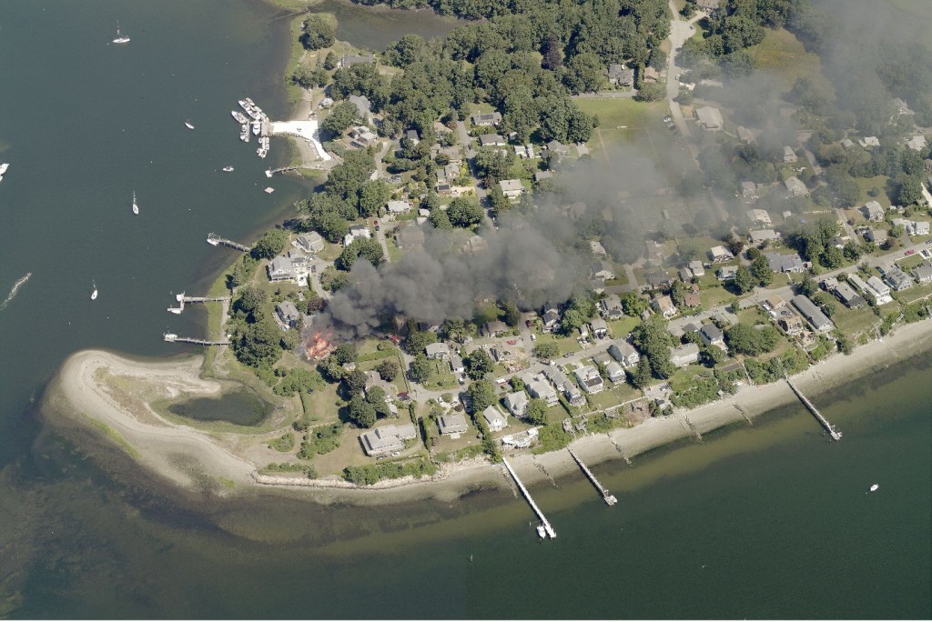
Stop by our booth to meet our team of experts and learn about the cutting-edge benefits of EagleView’s high-resolution aerial imagery for public safety. Discover how our 1-inch GSD (Ground Sample Distance) imagery provides unparalleled detail and context, crucial for first responders and emergency management teams.
Experience the Power of 1-Inch GSD Imagery
At our booth, you can:
- See a Live Demo: Witness firsthand how our 1-inch GSD imagery can enhance situational awareness, helping to identify hazards and plan responses with greater precision.
- Explore Integrations: Learn how EagleView’s imagery integrates seamlessly with various public safety software, including Computer Aided Dispatch (CAD) systems, to provide accurate location information and critical site details.
- Discuss Use Cases: Talk to our experts about real-world applications of our technology, from 911 dispatch and law enforcement to fire, rescue, and emergency management.
Why EagleView?
EagleView’s oblique and orthogonal aerial imagery offers numerous benefits for public safety departments, including:
- Accurate Caller Location: Quickly pinpoint the exact location of 911 callers using high-resolution imagery combined with cell tower data and visual landmarks.
- Enhanced Decision Making: Improve situational awareness with clear visibility of incident sites, even in challenging conditions.
- Safety and Efficiency: Identify potential hazards, plan safe routes for responders, and reduce response times.
Connect with Us
Our team is eager to share insights and answer your questions about how EagleView’s innovative aerial imagery solutions can support your public safety operations. Whether you’re looking to enhance your department’s emergency response capabilities or integrate advanced geospatial data into your workflows, we have the tools and expertise to help you succeed.
Mercer County Uses EagleView to Save Lives
The county has relied on EagleView for more than a decade to save lives, improve teamwork and protect first responders.
Watch our video to learn why the county’s leaders consider EagleView a critical public safety resource.
Don’t Miss Out
Make sure to visit Booth #917 at the NENA 2024 Conference & Expo to see how EagleView’s aerial imagery can transform your public safety operations. We look forward to seeing you there and helping you discover new ways to protect your community with the power of high-resolution aerial imagery.
For more information and to register for the conference, visit NENA 2024 Conference & Expo.
EagleView has exactly the imagery solutions you need to match to your priorities and budget. We look forward to seeing you there!